 |
Mayo Village is located north of a humid continental climate, but south of the polar tundra within the frozen interior of Canada. Mayo exemplifies all the characteristics of a subarctic, taiga climate (Dfc). These climates tend to undergo long, and severely cold winter with little sunlight and a very short, mild summers with an abundance of low angle insolation. Subarctic climates characteristically exhibit large annual temperature ranges because of the large differences in winter and summer weather and very short or no spring/autumn seasonality; Mayo’s annual temperature rang is ~70 °F. Graphic Source: Kottek, M., J. Grieser, C. Beck, B. Rudolf, and F. Rubel, 2006: World Map of the Köppen-Geiger climate classification updated. Meteorol. Z., 15, 259-263. DOI: 10.1127/0941-2948/2006/0130. http://koeppen-geiger.vu-wien.ac.at/present.htm Edited: Qwyla Foutch, 2011 Nov |
 |
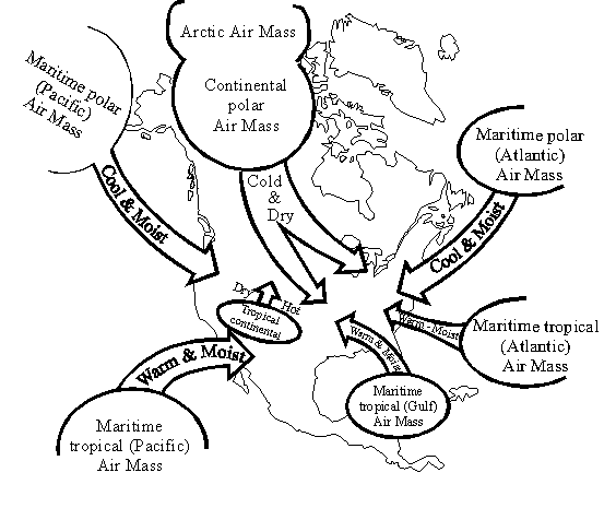
| The dominant Polar easterlies wind patterns in the Yukon region prepare this area to be a source for continental polar air masses. Below freezing surface temperatures during the winter are not suitable for rising parcels of air and dry, stable, high-pressure systems occur. In the summer, movement of the sun increases received solar insolation. The seasonal shifting of the pressure systems causes a weak, pressure trough to occur and greater precipitation ensues. The accumulation of a deep snow pack in winter is dependent on the lack of insolation required for melting. Most precipitation actually falls in the form of rain during the summer months. Graphic Source: Sabahat, S. Topic: Geography. Css Forum. http://www.cssforum.com.pk/css-optional-subjects/group-d/geography/48830-topic-wise-geography-notes-physical-geo-5.html Accessed: 2011 Nov 29 |
 |
Taiga climates are associated with the northern coniferous forests like those found in around Mayo Village. The vegetation here is primarily comprised of scrawny spruce, fir, larch and birch trees. The Mayo community tries it's best to moderatesintrusive species, and because of the small populous they've been successful. Graphic Source: Donohue, C. Skolai Images. http://www.skolaiimages.com/stock/displayimage-1009-Taiga-Forest-boreal-forest-Yukon-Territori.html Accessed: 2011 Nov 29 |
Macroscale climatic controls in Mayo are it’s northern, near arctic latitude and continental location. Mayo Village lies at a latitude of 63.6° N, just outside the Arctic Circle. Consequentially, this region experiences minimal solar radiation at an extremely low angle in the winter, and maximum solar radiation at a low angle during the summer. The seasonal variability in insolation is reflected in large annual temperature ranges. Mayo has an annual temperature range of ~70°F and it’s latitudinal locale explains why Mayo is so cold in winter (no sunlight) and fair in summer (~20 hours of low angle sunlight). The movement of the sun in respect to the earth also drives the shifting of pressure systems that effect Mayo’s climate (read below).
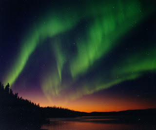
Graphic Source: Milan, S. university of Leicester, Dept of Physics. Updated: 2007 Oct. http://www.ion.le.ac.uk/~ets/phd/RSPP_PhDs.html Accessed: 2011 Nov 29
 Mayo Village is full of alternating valleys and highlands, making this region very particular to massive downslopes movements of cold, dry katabatic winds from the highlands that settle in the valley village of Mayo. The cold air ponding can lead to extreme decreases in temperatures in the lowlands, limiting flora growth to certain elevations. The effects of cold air ponding are intensified in Mayo winter because the area is already bitterly cold. The lowest temperatures within the Yukon Territory occur because of this phenomenon.
 Graphic Source: Edwards, M. 2009. Mt Haldane, Downtown Mayo Yukon. http://www.flickr.com/photos/michael_edwards/3328053071/. Accessed: 2011 Nov 30.
Mayo Village’s semi arid affection is an outcome of high pressure systems, polar wind patterns, and orographic blocking. Mayo Village is located in the dry shadow of the leeward side of the most northern part of the North American Cordillera Range. The rain shadow that occurs in Mayo is a result of the St Elias range that blocks the warm, moist air from the North Pacific Ocean and the Mackenzie Mt range to the north which disrupts any maritime effects from the Bering Sea. The most precipitation the area receives is during the summer because of weak convective, cyclonic system and the surplus of water via evapotranspiration processes. Graphic Source: Peepre,J. http://www.yukonwildrivers.ca/?page_id=9 Accessed: 2011 Dec 1.
The graphs above represent the total precipitation and mean temperatures in the months of January and July from 1925-2011. The trend on the temperature graph indicates that Mayo’s climate is getting warmer, especially in the winter. The trend on the precipitation graph illustrates in increasing amount of precipitation in the summer months. The climographs are also a great representation of the contrasting climate differences between summer and winter that are characteristic of subarctic regions.
Graphic Source: Graph made by Qwyla Foutch, data source:
National Climate Data and Information Archive. http://www.climate.weatheroffice.gc.ca/climateData/hourlydata_e.html?timeframe=1&Prov=XX&StationID=1572&Year=2011&Month=12&Day=1 Accessed: 2011 Nov 30.
Additional Sources:
Lutgens, F.K. Tarbuck E.J. 2010. The Atmosphere: An Introduction to Meteorology. Pearson Education. Chapter:15
Pojar J, Stewart AC. Chapter 17: Spruce-Willow-Birch Zone. http://www.for.gov.bc.ca/hfd/pubs/docs/srs/Srs06/chap17.pdf Accessed: 2011 NOV 30


No comments:
Post a Comment